
KLFT-Lafayette Regional/Paul Fournet Field Airport
Located 02 miles SE of Lafayette, Louisiana on 746 acres of land.
Surveyed Elevation is 41 feet MSL.
Services Available
Fuel: 100LL (blue), Jet-A
Transient Storage: Hangars,Tiedowns
Airframe Repair: MAJOR
Engine Repair: MAJOR
Bottled Oxygen: LOW
Bulk Oxygen: HIGH
Other Services: AIR FREIGHT SERVICES,AVIONICS,CARGO HANDLING SERVICES,CHARTER SERVICE,PILOT INSTRUCTION,AIRCRAFT RENTAL,AIRCRAFT SALES
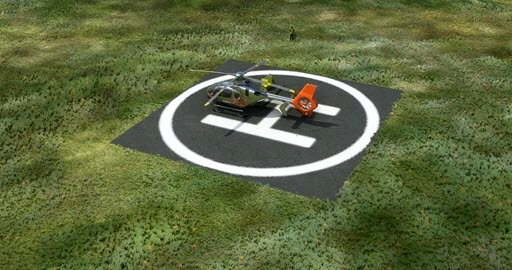
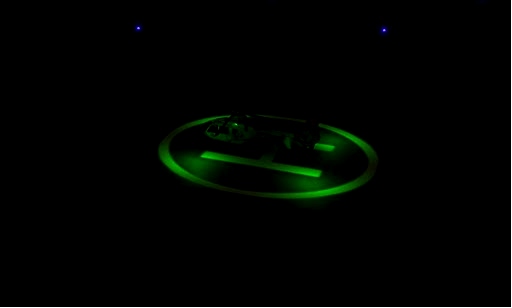
- added 3 Helipads with lights
- added light for fuelstation
- parking spots are at the end of the list parking 1,2,3
If you use LittleNavMap you can import you scenes and you will get the new information.
Enjoy the new helipads
Other Remarks
RY 11/29; RY 04L/22R & RY 04R/22L LGTD DISTANCE REMAINING SIGNS.
TWY B BTN TWYS C & D CLSD TO ACFT WITH WINGSPAN OVER 80 FT.
CTC GND CTL PRIOR TO PUSH BACK FM TERMINAL.
TWY F SOUTH OF TWY B REDUCES TO 40 FT WIDE.
Nearby Airports with Instrument Procedures
ID Name Heading / Distance
Acadiana Regional Airport KARA Acadiana Regional Airport 151° 11.4
Abbeville Chris Crusta Memorial Airport KIYA Abbeville Chris Crusta Memorial Airport 200° 14.6
St Landry Parish-Ahart Field Airport KOPL St Landry Parish-Ahart Field Airport 344° 21.9
Eunice Airport 4R7 Eunice Airport 304° 27.5
Jennings Airport 3R7 Jennings Airport 273° 35.7
False River Regional Airport KHZR False River Regional Airport 040° 40.5
Welsh Airport 6R1 Welsh Airport 273° 43.9
Harry P Williams Memorial Airport KPTN Harry P Williams Memorial Airport 131° 45.0
Bunkie Municipal Airport 2R6 Bunkie Municipal Airport 344° 46.8
Baton Rouge Metro, Ryan Field Airport KBTR Baton Rouge Metro, Ryan Field Airport 065° 47.7
Allen Parish Airport KACP Allen Parish Airport 312° 48.8
Marksville Municipal Airport KMKV Marksville Municipal Airport 355° 53.4

 rcla39652

