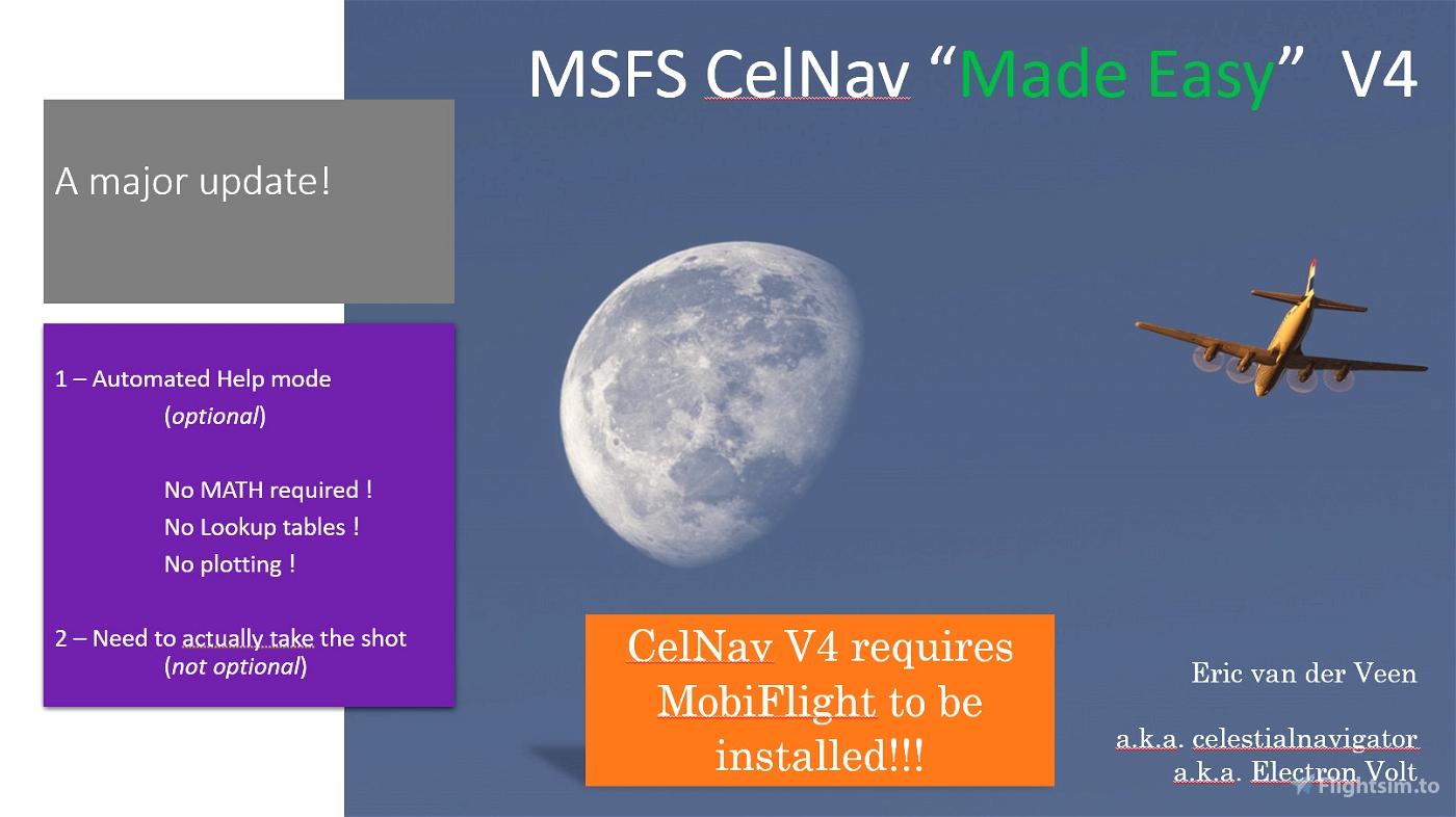
Description
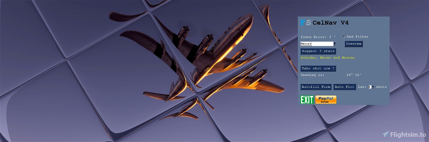
This add-on for MSFS simulates the basic function of an airborne sextant or octant. It allows the practice and application of Astro navigating in MSFS by the Sun, Moon, the four navigational Planets and over 50 stars.
But why?
Air navigation by sextant is an art to is about to go extinct. This is my modest contribution to keep the art alive and bring it into reach of a greater audience.
Installation
Unzip the file to a folder of your choice.
You need to have Mobiflight installed!!
Use
This add-on runs outside of MSFS. It requires some alt-TAB.
Run the application after running MSFS.
This add-on may be use with any aircraft, ship, or car in MSFS.
Tutorial
The zip file contains an extremely detailed step-by-step guide with sources and references.
This is advanced stuff. Be prepared.
Included and excluded
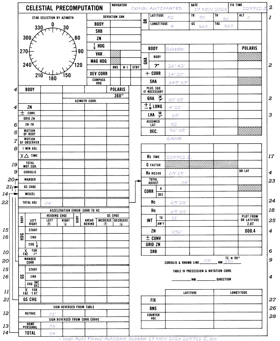
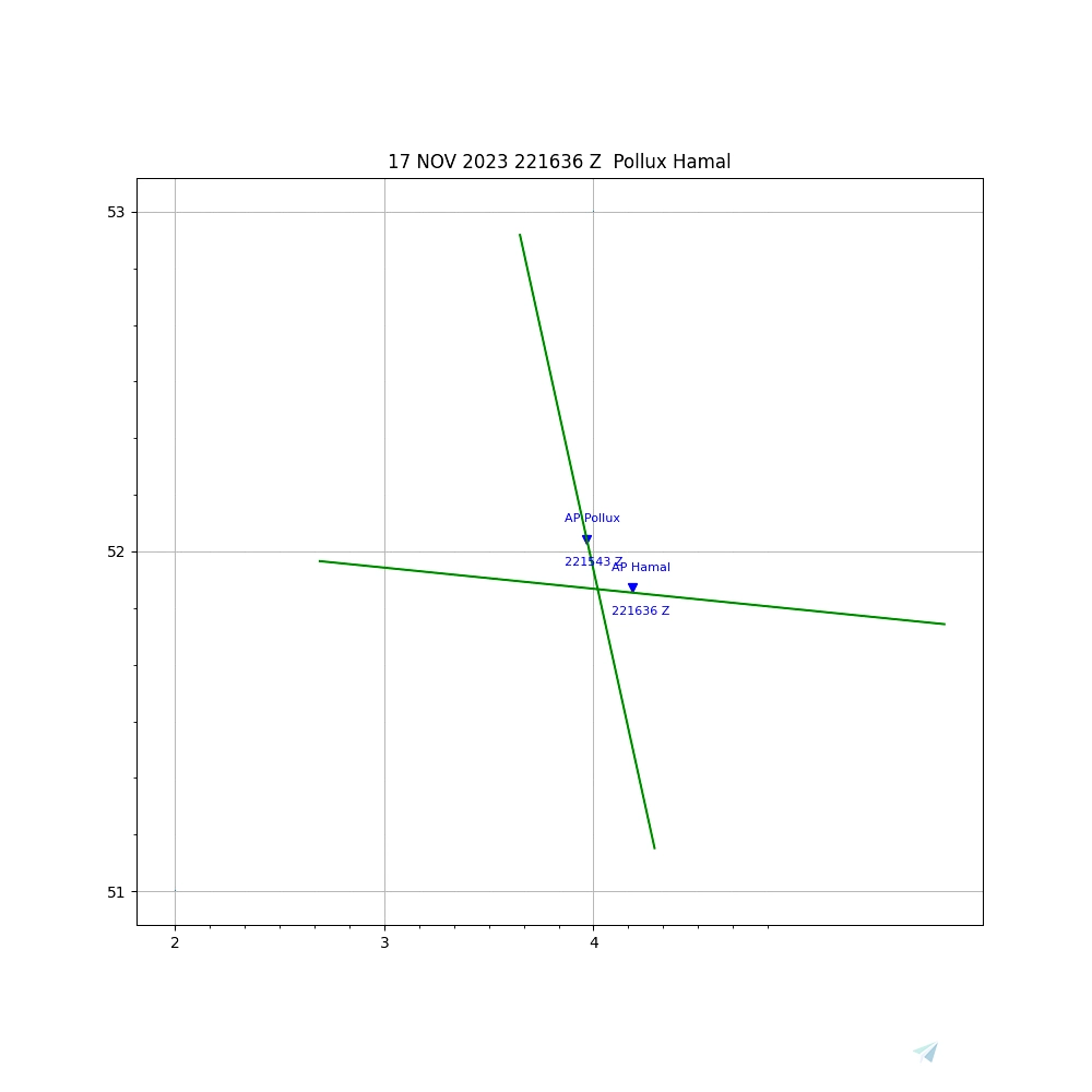
The add-on includes the following effects and corrections:
- Index Error
- Random user error
- Coriolis correction
- Refraction
- 2-minute shooting time
- Cannot shoot bodies below horizon
- Cannot shoot stars & planets in until nautical twilight
The data file is valid for dates from March 1900 to February 2100.
Not included are Precession and nutation, semi-diameter, dip. Parallax for the Moon only.
Video
A very short video on its use during a very long flight is here:VIDEO
A new video to help filling the forms is here: Video
Limitations
The add-on does not check for visibility through fog and clouds.
Discord support
No support is offered beyond a discord channel “MSFS Astro Navigators Lounge”: DISCORD
Acknowledgement
A big and special thanks to Capt. Arash, Alyson Johnson, Papa_red, Andrew Crowley, piedmonitor, Rob Jones and many others for their endorsement, testing and dev support of the add-on and to Tom Harnish for his superb improvement of the step-by-step guide
Please send suggestions to the discord channel.
July 2021, Eric van der Veen.
52°04’N, 4°14’E (Approximately)

 ElectronVolt


fillikirch
twodogzz
TonyTheFlyer
ElectronVolt author
7 months ago
TonyTheFlyer
"Failed to execute script pygame celnav 038"
"Error: local variable 'mrot' referenced before assignment"
"Tracback:
Also, the size of the windows starts out large, then after a few shots goes small. Not quite too small to use, but it'd be nice if you could scale the window size. Also, a darker night mode would be nice, and easier on the eyes.
Kassadgla
7 months ago
Ferryolmos
Nice one
FlyingsCool
You should add "Sextant" to the "predefined tags" of your addon page here. I searched for "Sextant" and your app didn't show up.
iborg
Well, I'm probably never going to use this, but kudos on keeping the hardcore old-school navigation thing alive!
Ginete
Ty!
Ferryolmos
Many thanks Sir
PinoStehle
Will there be a way to pause the game in the future? I just can't sit at the PC for several hours. Does anyone have any idea how to do it anyway? That would be just great.
ElectronVolt author
The best solution would be to use time acceleration between shots.
3 years ago
Big_Dipper
Excellent stuff! Now we need a gyrocompass that we can set to grid, and then rate the drift/wander. I did some polar stuff in the DC-6 but without a good compass controller, it was a mess.
ElectronVolt author
I was thinking of doing a polar sun compass that SAS airlines used.
3 years ago
Tofu1
could you post a new discord link? all of the ones are expired. trying to get some help using the sextant thanks
ElectronVolt author
Sorry, I FINALLY figured out why the link keeps expiring. The following should not expire: https://discord.gg/vtpde4ufsg
3 years ago
chague
This addon is wonderful and takes me back to my time doing celestial navigation in KC-135s. Very realistic. Well done!
FredExpert
Hey guys this is an amazing tool and I was hoping to join your discord however none of the invites in the description or comments seem to work.
ElectronVolt author
Try this one: https://discord.gg/vtpde4ufsg
3 years ago
Waydalf
A big thank you electronvolt. I was reticent at first to learn it, and then loaded the dc-6, searched and found an old flight computer (for speeds and wca) and to be honest, i did not have that much fun during a long haul flight in a long long time.
Again a big thank you.
Request : i want to create a blank landfall table (jpg or bmp, with only the lines on the x and y axis, to be used on all latitudes and for 60 minutes), but did not find online a tool that will help me. Is there a name on ur mind ?
ElectronVolt author
Waydalf, happy to hear! If you check into the discord channel, and the version-history subchannel. there is a download there of an EXEL for the Landfall, with autoformat of the axes. Discord is here: https://discord.gg/yKwZhPDJ
3 years ago